

Between the Lakes Treaty
By Dr. David Shanahan
On December 7, 1782, an agreement was signed between Mississauga Chiefs and officials representing the Crown, which confirmed and amended the taking of three million acres of land for the purpose of settlement. It was an enormous area of land, and the purchase was originally negotiated in May 1784.
Following the American Revolution, thousands of refugees found themselves exiled from their lands and territories in the new United States and had to find a place to live north of the new border. These refugees were not just the 8,000 or so white Loyalists, for whom land had to be found. It also included large numbers of the Six Nations who had taken the side of Britain in the conflict. In 1783, a treaty was made with the Mississauga to make land available around the Bay of Quinté for the two Six Nations groups under the leadership of Desoronto and Joseph Brant. However, Brant’s people decided not to settle there and looked for lands on the Grand River, further west. In 1784, about 1,843 individuals began settling along the river on lands ceded to the Crown by Treaty on May 22 of that year.
The territory between Lakes Ontario and Erie was Mississauga land, and Governor General Haldimand sent William Crawford to negotiate a treaty with the Chiefs. Deputy Surveyor-General John Collins, with an Interpreter named John Rousseau, accompanied Crawford. They found the Mississauga very open to a treaty that would provide lands for the Six Nations, whom they said were “one of the same people” as themselves.
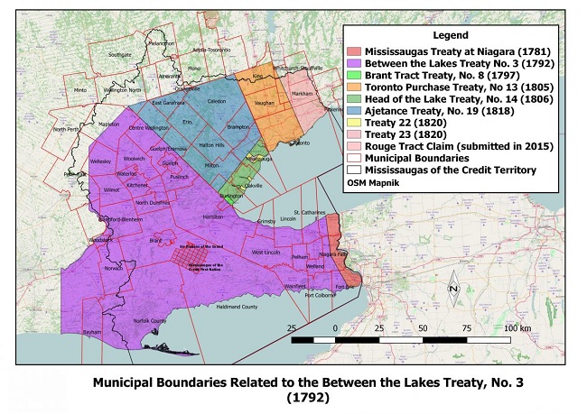
Given the welcoming attitude of the Mississauga, the Crown’s representatives negotiated a far larger area than simply the Grand River tract required by Joseph Brant’s people. What they acquired was all the land between the two Lakes, about 3 million acres in all, which included the entire Niagara Peninsula, the shore of Lake Ontario from present day Hamilton east to the Niagara River, and the north shore of Lake Erie from the Niagara to Cat Fish Creek. In return, the Mississauga received £1,180 in goods. They also agreed to allow roads to be built through their territory and free navigation of rivers and lakes.
However, it was soon discovered that the description of the lands included in the purchase was inaccurate, as so many of these documents were. This was mostly owing to the relative ignorance of the British officials about the actual geography of the country they were dealing with. Given the large area covered by the treaty, it is not surprising that the description of the lands included was not completely accurate. An amendment to the Treaty was negotiated and signed on December 7, 1792, correcting the description and reiterating the right to build roads and have free navigation through Mississauga lands.
The new treaty explained in simple terms why it had to be made:
“And whereas at the time of executing the said Indenture the boundaries of the said parcel of land were on one side described by an imaginary line running from the small Lake Washquarter in a north-west course until it strikes the river, but from an actual survey it has been discovered that a line from the said Lake Washquarter carried on a north-westerly course will not strike that sake River La Tranche.”
In the end, in a negotiation that was originally designed to provide sufficient land for the Brant Six Nations along the Grand River, the Crown actually took 3 million acres of land. This tract of land has proved extremely valuable, including within it the urban areas of Hamilton, Cambridge, Waterloo, Guelph, Brantford, and St. Catharines. Quite a bargain for £1,180 in goods.